Because it is a crossing and another car is not available for the return trip from Chiareggio, it is possible to take the bus back to Chiesa, which runs along Via Nicolò Rusca. When possible, however, it would be preferable to arrive by car at Primolo, continuing beyond the village to the end of the dirt road (about 1350m).
Description
Parking your car on the road leading to San Giuseppe, you will see the road sign 'Primolo 4 km' on the left. Follow this for about 300 m until you find a mule track on the right, marked with red and white stripes, which leads through the woods to Primolo (1274 m). Just before the village, several signposts are visible on the left and a small path rises through the coniferous forest. At an altitude of 1350 m, turn sharply to the right until joining the dirt track coming from Primolo. At this point, on the left-hand side of the road, there are several signposts for the various localities and for the Bosio refuge. Instead, follow the signpost on the right indicating Alpe Pradaccio at 50', as this is the most direct route. The path, which is fairly narrow but nevertheless comfortable and with a constant gradient, never too steep, passes above the Prato Alp (1620 m) where it meets the path coming from the Bosio hut on the second stage of the Alta Via della Valmalenco, marked by triangles of yellow paint. The path continues briefly through a beautiful larch wood until it opens out onto a wide plain where Alpe Pradaccio (1725 m) is situated. Having passed the clearing, continue northwards through a wood of mugo trees to the start of the Sassersa gully, where the slope becomes steep and constant, on a stony ground, up to an altitude of 1960 m. The path now bends to the left over bands of boulders, taking us to the centre of the gully. Here it is possible to intercept the track of a variant of the Alta Via that comes directly from Alpe Giumellini and allows a reduction in the route of the second stage. Cross a stream and continue walking on stones to the opposite side of the gorge until reaching what appears to be the final threshold of the valley. In reality, at an altitude of 2360m, the slope flattens out on the basin of glacial origin that is home to the three Sassersa lakes, located at different altitudes in tiny contiguous cirques. Take the track upstream of the first small lake towards Passo Ventina. We pass another basin, walking among scree, large boulders and a few snowfields until we reach the Ventina pass notch, characterised on its right by a large flaky rock. From the pass (2675m), there is a grandiose panorama of the Disgrazia group and its glacier, as well as of the splendid Val Ventina, where it is possible to see the roofs of the alp of the same name, as well as those of the Ventina (white) and Gerli-Porro (bright red) huts. From the pass, it is necessary to carefully descend the steep section on fine, unstable ground to the right of the snowfield and, where the slope permits, to use the remaining snowfields to facilitate the route. Descend to 2200 metres, aiming for the moraine of the glacier, which you follow until you reach the path that enters the valley. Now on the level, but still overcoming a few rocky stretches, you reach Alpe Ventina and the two huts mentioned above. In front of the Gerli-Porro hut is a signpost indicating the Vittorio Sella glaciological path, which illustrates all the stages of the withdrawal of the glacial front over the last two centuries. Behind the hut a comfortable mule track starts, which leads to Chiareggio in about 50 minutes. Cross the wooden bridge and descend to the right for two hundred metres and on the left, at the car park, is the bus stop for Chiesa.
.
Share
We have been there
Edited by:
Massimo Martini
Tuesday 28 July 2009
Passo del Ventina
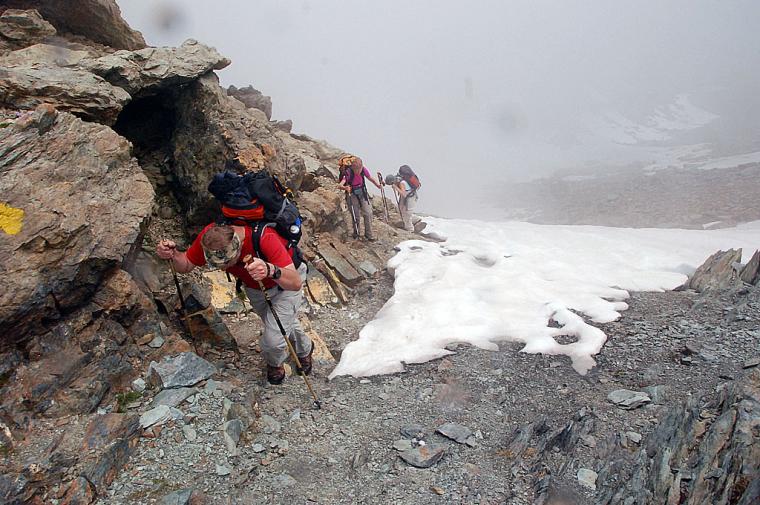
Nella seconda tappa dell'Alta Via della Valmalenco abbiamo avuto il piacere di condividere il percorso con Ermanno e Rita.
La salita al Passo del Ventina è veramente dura, ma al termine dell'ascensione la soddisfazione è stata grande: peccato che per discendere al Rifugio Porro-Gerli ci ha atteso una serie di impegnativi passaggi su nevai.
Nel complesso la traversata è molto dura e, per goderla al meglio, va affrontata in stagione avanzata in modo da non dover percorrere i nevai in discesa.
Nella seconda tappa dell'Alta Via della Valmalenco ho avuto il piacere di condividere il percorso con Ermanno e Rita.
La salita al Passo del Ventina è veramente dura, ma al termine dell'ascensione la soddisfazione è stata grande: peccato che per discendere al Rifugio Porro-Gerli ci ha atteso una serie di impegnativi passaggi su nevai.
Nel complesso la traversata è molto dura e, per goderla al meglio, va affrontata in stagione avanzata in modo da non dover percorrere i nevai in discesa.
Nella seconda tappa dell'Alta Via della Valmalenco abbiamo avuto il piacere di condividere il percorso con Ermanno e Rita.
La salita al Passo del Ventina è veramente dura, ma al termine dell'ascensione la soddisfazione è stata grande: peccato che per discendere al Rifugio Porro-Gerli ci ha atteso una serie di impegnativi passaggi su nevai.
Nel complesso la traversata è molto dura e, per goderla al meglio, va affrontata in stagione avanzata in modo da non dover percorrere i nevai in discesa.


Comments (0)
Sign in to leave a comment