Leaving the motorway at the Verrès exit, enter the roundabout and take the second exit. Proceed in the direction of the town centre and, after 300m, turn left onto the regional road for Val d'Ayas. Follow the regional road for 16.5 kilometres, passing the villages of Challand-Saint-Victor and Challand-Saint-Anselme, Brusson, Vollon, Extrapieraz, Periasc and Champoluc. After about 30 kilometres, you come to the large free car park at Frachey 🅿️ (where the Monterosa Ski rack starts): here the ZTL begins during the 7 a.m.-12 p.m. time slot. In the summertime there is a shuttle service that takes you to the little square of Saint-Jacques in three minutes with rides every 20 minutes. If you arrive before 7 a.m., you can leave your car in the free car park 🅿️ in the Place de la Grotte, but there are only a few places.
[0h44'] - [30,1km] How to get there with GMaps How to get there with Apple Maps
These directions are based on direct verification carried out at the time of surveying the route so the information should be checked before embarking on the hike. We recommend using a GPS navigator or map app on your smartphone to get up-to-date and detailed directions.
Introduction
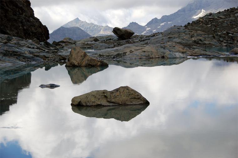
There are some not-so-well-known places that give the great fascination of discovery, or rather re-discovery. The Gran Lago di Tzère falls into this category: often forgotten or neglected because of the proximity of a more famous destination (Bivacco Città di Mariano n.d.r.), instead it really deserves a little extra effort. A mirror of glacial water set between the severe rocky spurs of Verra and the seracs of the Gobba di Rollin, it is not immediately visible but, at the right moment, leaves the hiker speechless!
.
Description
From Saint-Jacques, follow the signs for path
taking a small road that, after passing the parish church, runs alongside the Evançon stream until you reach a bridge: cross it and you will come to the start of the path marked by a plaque dedicated to the inauguration of the recent Sentiero Frassati. Take the beautiful paved road that runs alongside the stream for about a hundred metres then, after crossing a small wooden bridge, continue towards the larch grove. The paved road becomes a path and jumbles haphazardly into several small paths that soon lead to a fork just below Fiéry. Disregard the path to the left that leads to Fiéry and continue on path (7); you will skirt a clearing where the former alpine house is located and enjoy a fine view of the not too distant Castor. The path re-enters the forest and with a series of twists and turns takes on height; just before entering the not far Pian della Verra, you will find, on the left, the entrance to the path marked TMR, Tour du Mont Rose. Continue to the left, following the signs for Alpe Vardaz. Follow the path, which quickly takes you to the foot of a rocky rampart; make a wide curve to the left until you reach a beautiful balcony overlooking the valley below. The path briefly skirts a small stream and leads to a hump overlooking a pleasant clearing. Proceed halfway up the hillside, leaving the bucolic clearing to the left; climb up a short hump and you will find yourself on a lovely grassy basin crossed by a placid little stream. Follow the path along the stream as far as a nice little wooden bridge: go over it and now proceed up the grassy ridge until you reach the plateau before Alpe Varda. Before reaching the ruins of the mountain pasture, you will come to a fork in the path: proceed to the right, following the path (6C). Start climbing again along the splendid grassy slopes that precede the Palon di Tzère; after an initial uphill stretch on the hillside, you reach an undulating plateau from which there are interesting views of the distant Cime Bianche. Now head towards the bivouac, a red dot in the distance below the Gobba di Rollin; the path climbs the eastern slope of the Palon di Tzère and reaches the ruins of the Alpe di Tzère (2532m). Once past the ruins, the trail begins to encounter a harsher environment, crossing stony ground until it reaches a small saddle: from here, after a few short turns, it takes a rocky gully to the right. Once past the gully, the itinerary proceeds alternating between stretches of path and passages on small rocks: the destination is now near, turn left and finally reach the Bivacco Città di Mariano (2860m). From the bivouac, proceed in an easterly direction following a large group of cairns. The route is mainly on stony ground, with some ups and downs in the direction of the two towers of Verra. Go up a short morainic section to the top of the route: from here, the lake is already visible, descend towards it on mounded rocks until you reach the suggestive Gran Lago di Tzère. The return journey is along the same route as the outward journey.


Comments (0)
Sign in to leave a comment